UND Researchers Debunk "Inaccurately Derived" Satellite Images Of North Dakota Flaring
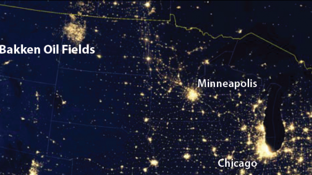
Back in 2012 and 2013 satellite photos showing western North Dakota lit up as though it were an urban center like Chicago or Minneapolis made national headlines. It was seen as an indicator of just how much oil and gas activity was taken place in the oil patch.
It also outraged some, and led to a push for a state crackdown on flaring (the North Dakota Industrial Commission has now capped flaring with very heavy fines for companies that exceed it).
But it turns out that those images which were used by the media and political activists were more than a little misleading, according to research conducted by the University of North Dakota’s Energy and Environmental Research Center.
You can read their “myth buster” post here, and their full report below, but to summarize their findings the images we all saw represented more than just light. They were picked up by sensors which measure things like temperature and nearly infrared wavelengths in addition to visible light. Plus, the report concludes that the “inaccurately derived flare images” used by the media and activists were “highly processed, manipulated, and often amplified 100×.”
In other words, western North Dakota is not and has never been lit up like some major urban center by flaring. The images we saw did not just represent visible light, and were manipulated to the point of extreme exaggeration.
Which isn’t to say that flaring in North Dakota’s oil fields isn’t a problem. Even with new flaring regulations in place about 20 percent of the gas produced in the state was flared off in March, the last month for which data is available from the Department of Mineral Resources (the target set by the state was no more than 23 percent flaring).
Still, the images were extremely misleading and gave the public a false impression of the flaring issue.