Secret gopher map reveals Washington agency’s power
By Melissa Genson | WatchdogWire.com
A secret 2013 Washington Department of Fish and Wildlife map that was accidentally placed in Thurston County Planning‘s public files has been obtained by Watchdog Wire.
The map purports to show locations of the newly federally protected pocket gopher.
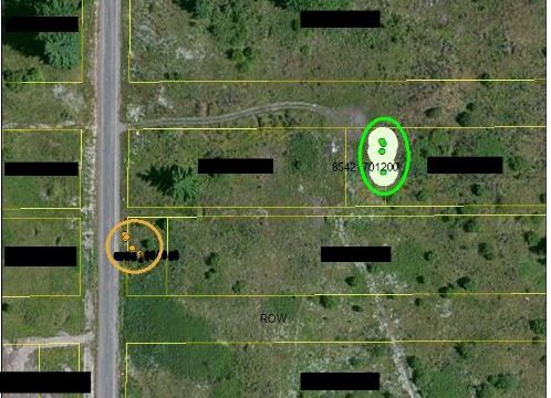
The WDFW map is from an aerial photo of rural land near the southwest Thurston County community of Rochester. Property boundaries are marked with yellow lines. Land outside the yellow lines are county right-of-ways. Except for Rochester real estate agent Larry Weaver‘s lot near the map’s center identified by the parcel number ending in -701200, all individual parcel numbers have been redacted. The alleged gopher locations are identified by “on-site” green and “off-site” orange dots.
WDFW map showing alleged locations of pocket gopher mounds on individual land parcels. Map by Tammy Schmidt, WDFW, found in Thurston County public records.
The map was to have remained unknown to the public, according to WDFW official Tammy Schmidt. Schmidt created the map of three separate properties after her Dec. 2, 2013, field visit, by placing the green dots with white circles and the orange dots on the parcel map. Schmidt describes how this map was created in her email at right.
These dots can criminalize something as simple as manicuring a lawn or planting a flower bed.
WDFW only had permission to be on one of these parcels, which belongs to Weaver. Although the green dots in white circles were to show “Weaver gopher mounds,” the dots and circles are clearly encroaching on a neighboring lot.